WGS has designed and built a proprietary oblique imaging system using five 50Mp sensors for a combined 250Mp acquisition resolution. At full speed, this system generates 578Mb/second at 3cm resolution. Typical applications are for urban areas for valuations, insurance and strategic planning but can also be used for quarries where information is required about vertical faces.
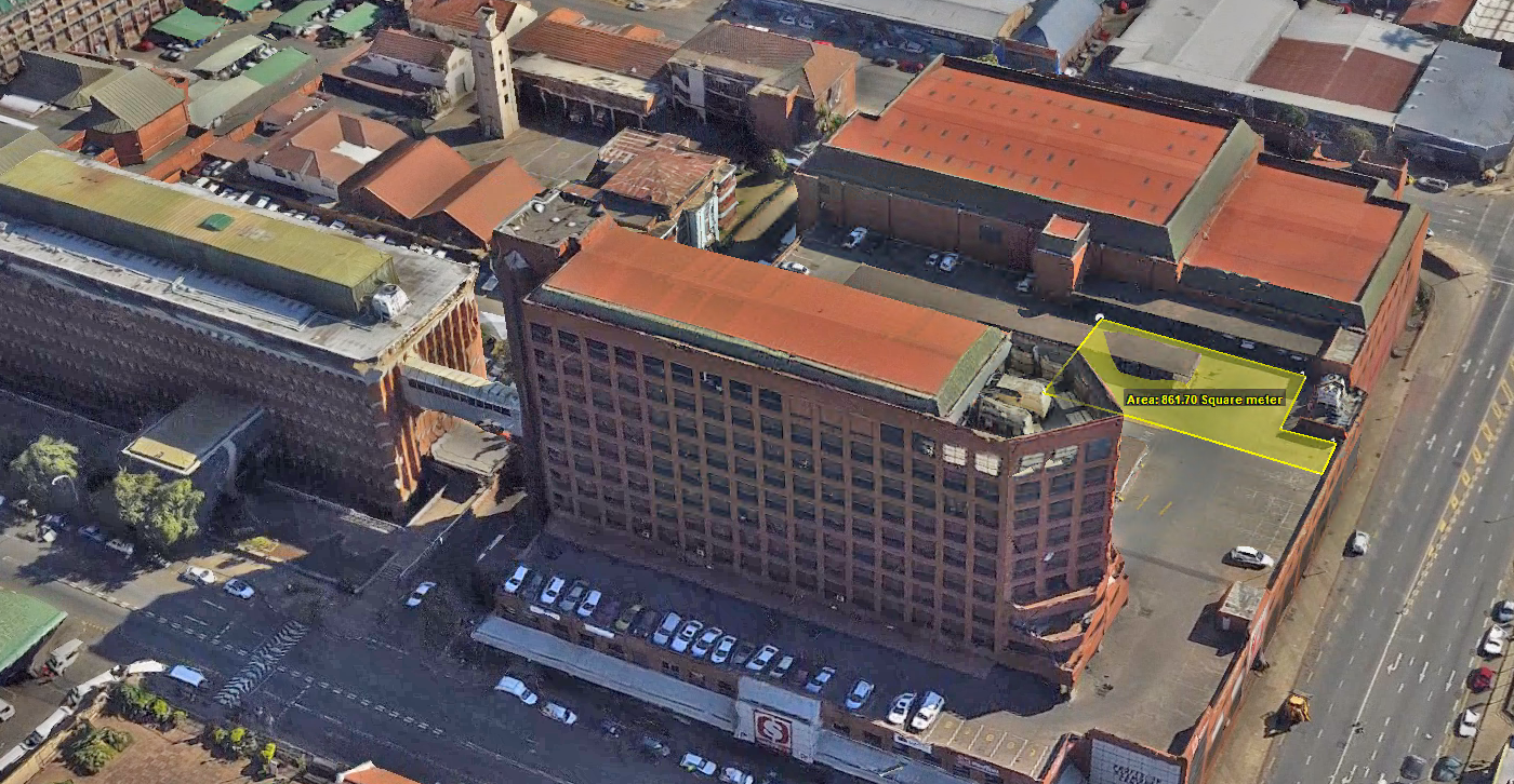
Oblique imagery is aerial photography collected at an angle, usually downward at a 40° to 50° angle to the ground and is used extensively to assist in the property value assessment process and public safety.
In the property valuation process, oblique imagery helps determine structure use by allowing views of the various elevations and perspectives.
Professional-grade aerial imaging cameras for superior picture quality.
Ideal for complex, large-scale projects requiring precise data.
Efficient data capture across challenging terrains and expansive coverage areas.
ACCURACY AND SCALE WITHOUT COMPROMISE
There are two delivery options available to clients. The first is to be able to view the oblique frames in a GIS environment. This can either be done in 3rd party software that we can provide or any other common GIS.
The second option is to supply a complete 3D model. This requires specialised software for viewing and interacting with but provides a far more immersive experience.
Professional-grade equipment ensures stable, high-quality output under various conditions.
SURVEY SOLUTIONS TAILORED TO YOUR NEEDS
COMPREHENSIVE OBLIQUE IMAGING CAPABILITIES
Geo-referenced aerial images with precise spatial accuracy for mapping and planning. High-Resolution DTM (Digital Terrain Models). Detailed topography data for land use planning and engineering. 3D Urban Modelling: Accurate 3D representations of urban areas for city planning and smart city projects.
OUR TOPOGRAPHIC MAPPING PROCESS
3-STEP PROCESS VISUALISATION:
1
Project Consultation
We start with a detailed consltation to understand your specific needs and project requirements, ensuring we tailor our imaging solution to your objectives.
2
Data Capture
Our experienced team uses large-format mapping cameras mounted on manned aircraft to capture data with pinpoint accuracy and wide coverage.
3
Data Processing and Delivery
After capturing the data, our team processes it for seamless integration into your workflows, providing high-quality deliverables ready for analysis.
Click here to view the full range of our services.
PRECISION DATA COLLECTION FROM OUR STRATEGIC BASES
OBLIQUE IMAGING COVERAGE
From our worldwide strategic bases, we provide aerial imaging services to clients worldwide. From urban centers to remote landscapes, our team has the capacity to capture high-resolution data wherever your project is located.
We are continuously engaged in fascinating projects with inspirational clients!
"Wooding Geospatial Solutions have come up with an effective solution to the problem we were faced with. Thank you and we are looking forward to working with this team on our next project!"
Scott V.
"The service was excellent. The survey that Wooding Geospatial Solutions did for us was handled efficiently and professionally. We were very happy with the reports. Highly recommended!"
James S.
"We received the data, and are extremely happy with it. From the quality of the imagery to the extent of the final deliverables, it’s easily one of the best Orthophotography projects we’ve been involved in."
Rob M. - Vermillion County
"The LiDAR data has been a HUGE help, not only for drill planning but we have also been able to find a bunch of new outcrops now have been in the forest."
Pete S. - Virginia Mining Corporation
"Wooding Geospatial Solutions is a professional organisation and all work has been delivered timeously and to specification."
Patrick G. - GeodesyGroup Inc.
START YOUR OBLIQUE PROJECT TODAY
Our team is ready to deliver precise, large-scale data to meet the unique needs of your project. Contact us today to discuss your requirements and receive a customized quote.